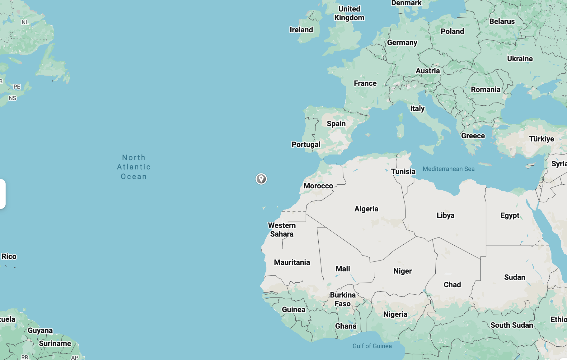
If you've ever looked at a map and wondered "wait, where exactly is Madeira?" — you're not alone. It's one of the most-asked questions from first-time visitors, and the short answer is: Madeira sits in the North Atlantic Ocean, about 1,000 km southwest of Lisbon and roughly 500–700 km off the coast of Morocco — closer to Africa than to mainland Europe, but politically, culturally, and historically 100% Portuguese (and part of the EU).
Where Exactly Is Madeira Located?
Madeira is a volcanic island in the North Atlantic, located at approximately 32.7°N, 16.9°W. It's the main island of the Madeira Archipelago, an autonomous region of Portugal. The island itself is small — about 57 km long and 22 km wide — but its location, isolated in open ocean between two continents, is what makes it such a unique stop on the map.
Madeira on the World Map: Europe or Africa?
This is the part that confuses people most. Geographically, Madeira is closer to Africa: it sits around 500–700 km north of the Moroccan coast, at roughly the same latitude as Casablanca. But Madeira is not part of Africa — it belongs to Portugal and has done so since Portuguese explorers settled the uninhabited island in the 15th century.
So on a world map, Madeira looks African in terms of position, but it's European in every way that matters for visitors: currency (euro), language (Portuguese), EU regulations, and governance.
How Far Is Madeira From Mainland Portugal?
Madeira is about 1,000 km southwest of Lisbon, which works out to roughly a 1h40 direct flight. It's further from Porto (around 1,200 km / 2-hour flight). Despite the distance, Madeira is fully integrated into Portugal as an autonomous region, with its own regional government but the same currency, laws, and EU membership as the mainland.
Madeira's Neighboring Islands (the Madeira Archipelago)
Madeira isn't alone out there. The wider archipelago includes:
- Porto Santo — the only other inhabited island in the group, about a 2.5-hour ferry or 15-minute flight from Madeira, known for its long sandy beach.
- Desertas Islands — a small, uninhabited nature reserve visible from Madeira's south coast on a clear day.
- Selvagens (Savage) Islands — a remote, protected nature reserve further south, administered as part of Madeira.
Zooming out further, the Canary Islands (Spain) are the nearest neighboring archipelago, about 450–500 km to the south.
How to Get to Madeira
Madeira is served by direct flights from most major European hubs, landing at Madeira Airport (Cristiano Ronaldo International Airport, FNC) in Funchal. Approximate flight times:
- Lisbon: 1h 40min
- Madrid: ~2h 30min
- Paris: ~3h
- London: ~3.5–4h
- Berlin / Amsterdam: ~4h
Quick Facts: Madeira's Location at a Glance
- Coordinates: 32.7°N, 16.9°W
- Ocean: North Atlantic
- Belongs to: Portugal (autonomous region)
- Distance from Lisbon: ~1,000 km
- Distance from Africa (Morocco): ~500–700 km
- Distance from Canary Islands: ~450–500 km
- Nearest inhabited neighbor island: Porto Santo
- Time zone: WET (UTC+0) / WEST (UTC+1) in summer
Frequently Asked Questions
Is Madeira in Europe or Africa?
Neither, strictly speaking — but if you're classifying it, Madeira is politically and culturally part of Europe (Portugal, EU), even though it sits geographically closer to the African coast.
What country does Madeira belong to?
Madeira is an autonomous region of Portugal, governed locally but part of Portugal and the EU.
How far is Madeira from mainland Portugal?
About 1,000 km from Lisbon — roughly a 1h40 flight.
Is Madeira closer to Africa than to Europe?
Yes, geographically. It's around 500–700 km from Morocco, compared to about 1,000 km from Lisbon.
What time zone is Madeira in?
Madeira follows WET (UTC+0) in winter and WEST (UTC+1) during daylight saving, the same time zone as Lisbon.